SCMAPS (South Carolina Maps and Aerial Photographic Systems)
SC MAPS is a middle school interdisciplinary curriculum supplement that offers a 500+ page Teaching Manual and a variety of maps, satellite images and aerial photographs that use the geographic regions of South Carolina as a framework for tying together both human and environmental history.
|
|
|
|
|
|
|
|
|
|
|
|
You don't have permission to access this tab.
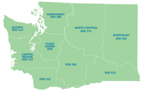 Please select the district(s) your located in. Used this map for reference.